The European Space Agency (ESA) has announced that the twin Sentinel-1 satellites have – for the first time – combined to show their capability for revealing even small deformations in Earth’s surface.
Following its orbital manoeuvres, the recently launched Sentinel-1B satellite reached its designated orbit position on 15th June. The satellite is now orbiting Earth 180° apart from its twin, Sentinel-1A, at an altitude of almost 700km. With both satellites finally in the same orbit, together they can cover the whole globe every six days.
The two-satellite ‘radar vision’ mission for Europe’s Copernicus programme carries an advanced radar to provide an all-weather, day-and-night supply of imagery of Earth’s surface. It has now been demonstrated that future images acquired by the pair can be merged to detect slight changes occurring between scans.
This technique is particularly useful for generating accurate maps of surface deformation over wide areas, such as those caused by tectonic processes, volcanic activities or landslides. It is also an ideal tool for monitoring glacier flow and changes in Arctic and Antarctic ice shelves.
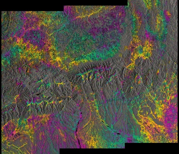
Sentinel-1’s first such paired ‘interferogram’ (image above) combined a Sentinel-1A scan over southern Romania on 9 June with a Sentinel-1B acquisition over the same area just one day before reaching its target orbit position.
The rainbow-coloured patterns are related to topography, and they demonstrate that the two satellites’ identical radars are accurately synchronised, pointing in the same direction and that the satellites are in their correct orbits. Once commissioning is completed in mid-September, the pair will be ready to deliver data for the systematic and routine monitoring of Earth surface deformation and ice dynamics.