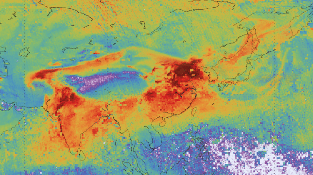
The first data on air pollutants from the Copernicus Sentinel-5P satellite have been released, showing a range of trace gases that affect air quality such as carbon monoxide, nitrogen dioxide and ozone.
Following months of tests and evaluation, the first data on air pollutants from the Copernicus Sentinel-5P satellite have been released. These first maps show a range of trace gases that affect air quality such as carbon monoxide, nitrogen dioxide and ozone.
Launched on 13 October 2017, Sentinel-5P is the first Copernicus satellite dedicated to monitoring the atmosphere. It is part of the fleet of Sentinel missions being developed by ESA for the European Union’s environmental monitoring Copernicus programme managed by the European Commission.
Thanks to its Tropomi instrument – the most advanced multispectral imaging spectrometer to date – Sentinel-5P can zoom down to the surface of Earth and deliver highly detailed and accurate data about the atmosphere.
With a resolution of up to 7 x 3.5 km, it can even detect air pollution over individual cities.
This higher spatial resolution is key to what makes the data produced by Sentinel-5P so useful. Tropomi also has the capacity to locate where pollutants are being emitted, effectively identifying pollution hotspots.
Initial data have highlighted air pollution as emitted by big cities and ship lanes through measurements of nitrogen dioxide over Europe, Africa, the Middle East, and India.
These new data also show the transport of carbon monoxide from India to China, and the closing of the ozone hole during 2017.
Having completed its commissioning phase, Copernicus Sentinel-5P data is now available to all, free of charge.
Copernicus Sentinel-5P will also contribute to services such as volcanic ash monitoring for aviation safety and warnings of high level UV radiation.

