Throughout the Proxima mission onboard the ISS from November 2016 to June 2017, French astronaut Thomas Pesquet took many superb photographs of Earth, which he posted on social media. Here, Lake Alaköl, in Kazakhstan.
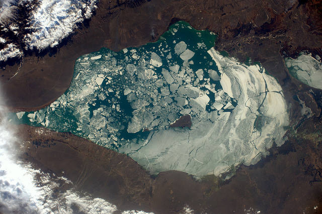
On 15th April 2017, Thomas Pesquet posted this view of Lake Alaköl in Kazakhstan with the following comment: "It’s not yet spring everywhere! A frozen lake in the Himalayas".
The image was taken from the ISS on 9th April, using a Nikon D4 equipped with a 140mm lens. North is at 4 o'clock. We are in the extreme east of Kazakhstan, just a few kilometers from the border with the Uyghur Autonomous Region of Xinjiang, China (northwest China).
Thomas Pesquet offers us a rare view of ice thawing on Lake Alaköl. This lake is located on the Silk Road, in the Oriental-Kazakhstan oblasts and in Almaty, two administrative regions of Kazakhstan. Less than 200km east of the famous Lake Balkhash (the largest in the country, not to be confused with Lake Baikal, located in Eastern Russia), it is a saline endorheic lake, meaning that its watershed is closed and retains all runoff and precipitation in a closed depression.
All water supplies (the lake receives the waters of 15 rivers including the Urzhar, Katynsu, Emelkuysa, Yrgayty, Zhamanty, Zhamanotkol and Tasty), but also rain and snow, do not leave the endorheic basin except by evaporation or infiltration. Lake Alaköl is located at an altitude of 347m, and has a surface area of 2,650km2 and a volume of 59km3. Its maximum depth is 45m and its watershed is 68,700km2.
On the right side of the photograph is a part of the smaller Lake Sasykköl, which has an area of 600km2 and which communicates with Lake Alaköl through a marshy area. Lake Sasykköl, also in thaw, is located northwest of Lake Alaköl, both constituting a state nature reserve. In fact, these lakes are connected to other, even smaller lakes and form a single system.
The zoom allows you to see the five islands of Lake Alaköl, all aligned along the same axis (the longest length of the lake) and the largest of which is about 5km long and 2-3km wide. The other islands are much smaller. All are important nesting and feeding grounds for many species of birds (including the Relict Gull, the rare, heavy and fragile Dalmatian pelican and the Eurasian white spoonbill). As such, in 2013, UNESCO integrated Lake Alaköl into the global network of biosphere reserves.
Finally, clean steppe air, warm and salty waters and lake chemistry (sodium chloride, sodium sulfate, bromine, fluoride ...) make this place a thermal and therapeutic centre for sick people and spa lovers ...
Find the image on Google Maps!
https://www.google.fr/maps/@46.2194381,81.5586137,174542m/data=!3m1!1e3?hl=fr
*Gilles Dawidowicz is a geographer, president of the Planetology Commission of the French astronomical Society.