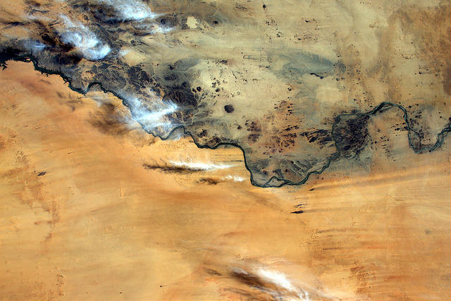
Throughout the Proxima mission onboard the ISS from November 2016 to June 2017, French astronaut Thomas Pesquet took many superb photographs of Earth, which he posted on social media. Here, the Nile, in Sudan.
On 10th March 2017, Thomas Pesquet posted this splendid view of the Nile, between Semna and Kokka in northern Sudan, with the following comment: "This river in Sudan seems to separate rock and sand like a border".
The image was taken from the ISS on 12th December, using a Nikon D4 equipped with a 65mm lens. North is at 7 o'clock. We are above the Nile in northern Sudan, 500km west of the Red Sea.
Sudan is a very large country of almost 1.9 million km2, with more than 35 million inhabitants. It is bordered by Egypt to the north, Libya to the northwest, the Red Sea to the east, Eritrea and Ethiopia to the southeast, Chad to the west, the Central African Republic to the south-west and South Sudan to the south. It is crossed (from south to north) by the Nile: the White Nile and the Blue Nile meet in Khartoum.
Semi-arid in the south and with desert areas in the north, Sudan is a vast plain lined with mountains to the east and west. With a shorter and less intense rainy season, desertification is progressing southward, accompanied by soil erosion.
The history of Sudan is marked by the military and cultural influence of its neighbours, including Egypt, the Arabian Peninsula, Ethiopia, the Republic of the Congo, the Democratic Republic of the Congo and Chad, the United Kingdom and the United States. Its territory overlaps several ancient kingdoms including the mysterious kingdom of Kush, and those of Darfur and Nubia.
Back to the photo by Thomas Pesquet. We are in Nubia (the Sudanese part, not the Egyptian part separated at the end of English colonization). As Thomas Pesquet points out, the Nile separates two very different landscapes seen from outer space. At the bottom of the photograph (i.e. on the western, left bank), we have a vast desert plain with all the characteristics of an erg (that is to say a vast expanse of sand and dunes accumulated by the winds).
At the top of the picture (on the eastern, right bank), the landscape shows more substantial relief comprising old, eroded control mounds and chaos culminating between 300 and 600m in altitude. Here, the desert has the characteristics of a reg (i.e. a vast stony expanse). Long, thin, dark trails on the ground attest to effective winds (left to right), over the whole area of the photograph.
The photograph extends from Semna to the left (on the right bank of the Nile), about 50km south of the border with Egypt, to Amara (in the centre of the photograph), about 120km to the south, to Kokka to the right of the picture (on the left bank of the Nile), which is about 100km south of Amara. We are in north-central Sudan.
As for the course of the Nile, besides a few meanders and ramifications, it is interesting to note the presence of many islands, some of which are several kilometers long. Here, its course is regular and its channel is rather calibrated and homogeneous. As elsewhere, the Nilotic corridor represents a manna (almost in the strict sense) interesting for agriculture, because of its continuous supply of fresh water and the fertilization of the soils that its floods entail.
A zoom on the image makes it possible to detect a narrow green corridor throughout its course. Unfortunately, wars and ongoing conflicts mean that less than 20% of the cultivable area is currently exploited. Sudan could be the breadbasket of Africa with a potential of 1 million square kilometers of fertile land, including cotton, sesame, peanut, sugar and arabic gum (from the acacia tree).
Last but not least, if only one of the splendours of Sudan was to be mentioned (very difficult to identify on the photo by Thomas Pesquet, but still present), it would be the remains of the temple of Amon located in Soleb to the right of the image, on the left bank of the Nile). There are at least 14 known Amon temples in the world, including Luxor in Egypt. The one of Soleb, located about 500km south of Aswan, was discovered in 1963.
It is the work of Amenhotep and was built on the occasion of the jubilee of Amenhotep III in the north of the kingdom of Kush. Constructed of a soft sandstone, it was likely already in ruins around 1000 BC (probably due to heavy rains). However, this temple testifies not only to the greatness of Egyptian art in the eighteenth dynasty, but also to its conquering ideology: the king was the guardian of order against the chaos of foreign countries.
Find the image on Google Maps!
https://www.google.fr/maps/place/Amara+West,+Soudan/@20.7499166,30.4027693,117951m/data=!3m1!1e3!4m13!1m7!3m6!1s0x15d91cc41072b195:0xd2bf70462a612b37!2sSoudan!3b1!8m2!3d12.862807!4d30.217636!3m4!1s0x1426bfae5fcad83d:0x99c971bd8692b5f!8m2!3d20.8129273!4d30.4904938?hl=fr
*Gilles Dawidowicz is a geographer, president of the Planetology Commission of the French astronomical Society.

