Throughout the Proxima mission onboard the ISS from November 2016 to June 2017, French astronaut Thomas Pesquet took many superb photographs of Earth, which he posted on social media. Here, Waw an Namus, in Libya.
On 19th February 2017, Thomas Pesquet posted this view of a Libyan oasis located in a volcanic crater, with the following comment: "Strange structure in Chad, surrounded by black sand. I still don’t quite know what it is".
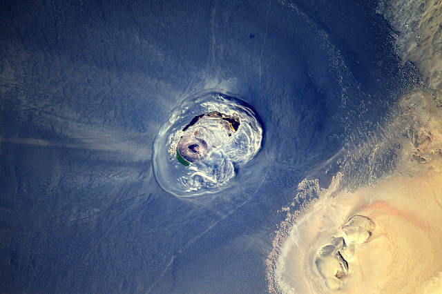
The image was taken from the ISS on 1st January, using a Nikon D4 equipped with a 1,150mm telephoto lens. North is at 7 o'clock. We are above the Mosquito Oasis, aka Waw an Namus, in southern Libya, in the centre of the Sahara.
The Sahara Desert is huge and beautiful. It offers exceptional and stunning landscapes. In addition to these landscapes of an incredible variety, with very different morphologies, the Sahara presents geological and geomorphological curiosities of the first order. Here is a new illustration in Libya. We are in the Mourzouq shabiyah (a local administrative subdivision), to be precise.
The Waw an Namus is located in a vast 3 x 4km depression, surrounded by a huge field of black volcanic rocks extending in a 15x20km ellipse. In the midst of the yellow sand desert, it stands out like a huge ink stain on a sheet of white paper!
Within this circular depression is a central peak, which is actually a volcanic cone at the top of which a caldera has formed. What is a caldera? It is a collapsed volcanic crater, often flat-bottomed, usually located in the summit of a volcano and originating from an eruption that emptied the underlying magmatic chamber. This 100m-deep caldera measuring 400m by 300m would have formed about five thousand years ago.
On the outer slopes of the volcanic cone, and around it, gullies and a geomorphology of drainage are observed, showing a very efficient runoff. They feed salt lakes located at the foot of the cone or not far away. A few meters in depth, these lakes of variable colours are 400-500m long and explain the appearance of an oasis of greenery in this mineral world. They lose more than half of their water each year due to intense evaporation but are replenished by virtually inexhaustible groundwater. It is possible that these lakes form only one during the highest waters, encircling a part of the cone. But quickly, under the effect of evaporation, they dissociate. In these lakes, despite the high levels of salts, mosquitoes proliferate, which explains the name of the oasis... The 547m-high volcanic cone surpasses by about 50m the edges of the circular depression.
Seen from space, this depression is like a bean or a brain. The photograph of Thomas Pesquet covers ¾ of this dark volcanic field composed of ejecta, pyroclasts, cinerites or tephras (in fact, the fragments of solid magmatic rock and ashes expelled in the air during the eruption of volcano). It looks like a cloud, a stain. Only the lower right corner of the image reveals the clear sands of the desert.
Find the image on Google Maps!
https://www.google.fr/maps/@24.9173041,17.7569555,10483m/data=!3m1!1e3?hl=fr&authuser=0
*Gilles Dawidowicz is a geographer, president of the Planetology Commission of the French astronomical Society.