On June 26 1978, an Atlas-Agena launch vehicle placed Seasat, the first American satellite entirely dedicated to studying the oceans, into Earth orbit.
In August 1969, Nasa organized a symposium in Williamstown (Massachusetts) on the theme of " the possibility of being able to make precise measurements of position, velocity and acceleration from space to the solution of geophysical and oceanographic problems ". During the symposium, the interest in developing altimetry techniques was highlighted.
Altimetry before Seasat
The first experiment with an altimeter from space was carried out in June 1973 from the American Skylab orbital station with the S-193 (or Radscat) instrument. This instrument took measurements of a wide range of sea conditions (tropical hurricanes, storms, etc.). Some 200 scans of ocean data were taken during the first two Skylab missions (June and August 1973), and a further 200 during the last mission (December 1973). This wealth of information also showed, pfor the first time, the presence of " holes " and " bumps " on the ocean surface, highlighting the complexity of the marine geoid.
Bolstered by this initial success, the US Navy placed an altimeter on board the Geos 3 (Geodynamics Experimental Ocean Satellite 3) satellite, launched on April 9, 1975. Interested in altimetry, France, under the impetus of engineer Michel Lefebvre, a pioneer of French space geodesy, proposed to the Americans, who hesitated for a while, to install antennas on the Kerguelen Islands, then on the island of Rangiroa (an atoll in the Tuamotu archipelago, in French Polynesia) and even in Kourou. In due course, this initial approach will pave the way for more extensive cooperation...
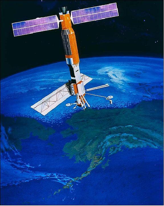
Seasat features
While the first altimeters are being tested on Skylab and Geos 3, thethe director of Nasa's Earth and Oceans programs, Frank Williams, and his deputy Ben Milwitsky, invite ocean scientists to meet to discuss a specific satellite mission called " SeaSat " (satellite of the sea). The aim is " to collect data on sea surface winds, sea surface temperatures, wave heights, ocean topography, internal waves, atmospheric water and sea ice properties ". To achieve this, the satellite, with a total mass of 2 300 kg, carries five main scientific instruments: an L-band synthetic aperture radar, a radar altimeter (to determine sea surface profiles, currents, wind speed and wave height), a microwave scatterometer (for wind direction and speed), a multichannel microwave radiometer (for monitoring sea surface temperatures, wind speed, rain rate, atmospheric water content), and a visible light and infrared radiometer (to provide images of visual reflection and thermal infrared emission from oceanic, coastal or atmospheric features).
Under the coordination of Gene Giberson, project manager at Nasa's Jet Propulsion Laboratory, the construction of Seasat was entrusted in 1976 to Lockheed in partnership with Nasa's Goddard Space Flight Center, but also the Wallops Island and Langley (Virginia) centers, the Glenn Research Center in Cleveland (Ohio), the Applied Physics Laboratory at Johns Hopkins University (Maryland) and Noaa - National Oceanic and Atmospheric Administration (Washington DC).
A premature end but promising results
Seasat was launched on June 27 (UTC) 1978 from Vandenberg (California) by an Atlas-Agena launch vehicle. Stabilized on three axes, it was successfully placed in a nearly circular 800 km orbit with a high inclination (108°). Once underway, Seasat'ssensors correctly collected data on a global scale, performing experiments at various locations.
Unfortunately, on October 9, 1978 (UTC), the satellite went silent, following a failure of the power supply system. During its 105 days of activity, Seasat nonetheless delivered a wealth of important data, enabling the production of various maps on iceberg hazards, wind and wave forecasting, storm location, etc., as well as refining knowledge of the ocean geoid. Scientists are also realizing that such a satellite can have other purposes, such as more efficient fisheries, better selection of offshore equipment, etc.
After Seasat
Seasat thus laid the foundations for many other programs, both American (Geosat, NROSS) and foreign, such as in Canada (Radarsat), Europe (ERS 1), Japan (JERS 1, MOS 2), the USSR, but also in France which, under the impetus of Michel Lefebvre, led to the Poseidon project (Premier Observatoire Spatial pour l'Etude Intensive de la Dynamique des Océans et de la Nivosphère). The latter joined forces in 1987 with the American Topographie Experiment to culminate in fine in Topex-Poséidon, a satellite that was placed in orbit on August 10, 1992, revolutionizing the way the oceans are studied, and inaugurating a whole line of satellites, the latest of which is Swot (Surface Water & Ocean Topography).
Some references
- A testimonial: Michel Lefebvre, marin de l'espace, Loubatières Sciences, Portet-sur-Garonne, 2008.
- An article: "Seasat; Results of the Mission", Robert H. Stewart, in Bulletin of the American Meteorological Society, vol.69, n°12, December 1988
- A book: Océan et climat, Jacques Merle, IRD Editions, Marseille, 2018
- The site eoPortal of ESA on Seasat, (the information communicated comes from Observation of the Earth and Its Environment: Survey of Missions and Sensors, Springer Verlag, 2002).
Philippe Varnoteaux holds a doctorate in history, specializes in early space exploration in France and is the author of several reference works.
Découvrez cet article sur Air&Cosmos